


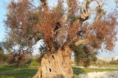
Identification of olive trees affected by Xylella fastidiosa before the onset of symptoms, through the processing of images acquired from satellite, aircraft, drone and terrestrial surveys, making monitoring activities quicker, more sustainable, precise and comprehensive.
This is the objective of the REDoX project launched by Planetek Italia in partnership with the Apulian Aerospace Technological District (DTA), the CNR with 4 institutes (IREA, IPSP, ISPA, IRSA) and ENAV. The project is financed with PON funds and eligible for MISE funding.
The expected benefits are the possibility of implementing monitoring programs on large areas that allow the timely identification of new outbreaks, the containment of costs related to monitoring activities, for the same area investigated, thanks to the reduction in the number of operators necessary for the investigations in the open field and to the reduction of sampling and laboratory analyzes that are carried out to certify the presence of infection.
The experimentation will be conducted in Puglia with the possibility of extending the tests to other areas of the Mediterranean basin where the olive tree is present.
In detail, the project aims to develop a set of technologies and procedures for the acquisition, transmission, storage, processing and sharing of remotely sensed data which are acquired with digital sensors mounted on satellite, aircraft, drone and terrestrial platforms for identification of olive trees infected by Xylella fastidiosa even before the onset of symptoms visible to the naked eye.
The algorithms for processing the images acquired with hyperspectral sensors and thermal cameras developed by the CNR, project partner and member of the DTA, will guarantee continuous monitoring of large areas, even tens of thousands of square kilometers such as an entire region, with high levels of accuracy and reduced costs compared to current ones.
New methodologies will be developed to identify with certainty infected trees and branches to be sampled or pruned and which, in the absence of drying symptoms visible to the naked eye, could be practically impossible to identify. To enable the use of swarms of aerial drones for monitoring large areas, innovative navigation services will be designed and developed by ENAV to be provided via air traffic management systems. The operational base will be Grottaglie airport.
Planetek Italia will take care of the design of the monitoring service, the development of the information system that integrates the different phases of the process and the marketing of the service on the national and international market.
More info on DTA Distretto Aerospaziale Pugliese website